Aircraft / Avionics Orders: 800.447.3408 Radio Control Orders: 877.219.4489
Garmin
GMN 010-02303-00
aera 760 7" Portable Aviation GPS Navigator with 3D Vision Technology
aera 760 7" Portable Aviation GPS Navigator with 3D Vision Technology
In Stock
$1,599.00
Garmin aera 760 7" Portable Aviation GPS Navigator with 3D Vision Technology
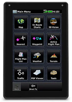
ADVANCED PORTABLE AVIATION NAVIGATION WITH A 7” DISPLAY
Fly confidently with Garmin's rugged, reliable, purpose-built GPS that includes the latest in-flight features, including IFR approaches, arrivals and departures, plus a familiar touchscreen interface.
In the Box: aera 760, Mount cradle with CLA power cable, USB-C 27W AC adapter, USB-C to USB-C cable, USB-C to USB-A cable, Quick start manual and related documentation
- Bright days are no problem — with the vivid, sunlight-readable touchscreen display.
- Make IFR flying easier by adding airways and IFR approaches, arrivals, departures and more to your route.
- Be aware down low. See obstructions and wires with Garmin's WireAware™ wire-strike avoidance technology.
- Weather and traffic? Check, and check. Just pair with a GTX™ 345 transponder or GDL® 52 series datalink.
- Prep for your flight with wireless Internet weather and automatic data downloads.
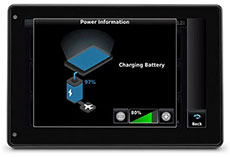
- Take off with round-trip power. Get up to 4 hours of battery life on each charge.
 |
 |
 |
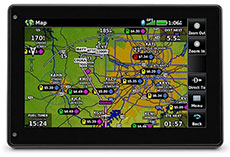
| BRIGHT SCREEN The large, sunlight-readable 7” touchscreen display is twice as bright as many tablets, with portrait and landscape display options and intuitive pinch to zoom and panning. |
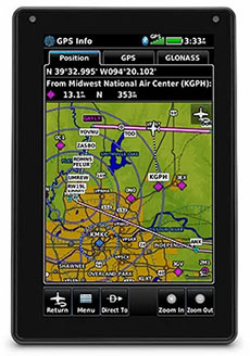
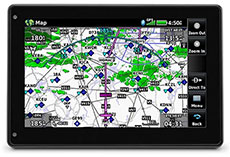
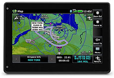
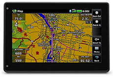
DYNAMIC MAPS Quickly and reliably acquire GPS and GLONASS satellite constellations to display rich, interactive, dynamically drawn and customizable aviation maps. |
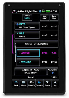
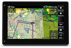
FLIGHT PLANS Creating flight plans is easy. Enter a starting waypoint and destination, then insert segments — including airways, as well as IFR departures, arrivals and approaches. |
 |
 |
 |
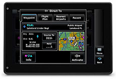
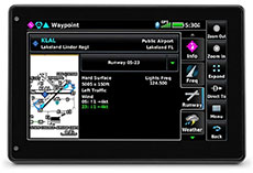
| DIRECT-TO NAVIGATION A Direct-to key on the screen lets you quickly enter a direct course for any selected waypoint. A menu of nearest airports and flight plan waypoints makes for easy entry. |
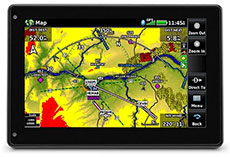
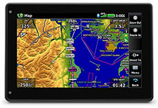
MAP TOPOGRAPHY View ground references — including airports, cities, terrain, obstacles and more — on the dynamic map display to easily determine your position on VFR flights. |
VFR SECTIONAL CHARTS View georeferenced VFR sectional charts for the U.S., Canada and Europe. |
 |
 |
 |
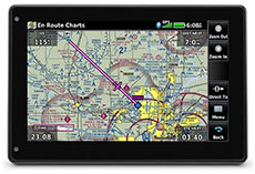
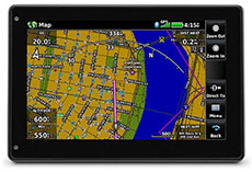
| IFR ENROUTE CHARTS Use IFR map mode to display and navigate on high or low enroute airways. Touch to view Minimum Enroute Altitudes and distances between intersections. |
COMM CONNECTION With an optional power/data cable, you can find and upload frequencies to select radios, including GTR 200 Comm radios, GTR 225 Comm radios, GNC 255 NAV/COMM radios and more. |
COCKPIT INTEGRATION Interface aera 760 with the G3X autopilot or GFC™ 500 digital autopilot for coupled lateral and VFR vertical guidance, and upload or download flight plans wirelessly to select navigators. |
 |
 |
|
| ADS-B DATALINKS With available Garmin ADS-B “In” equipage solutions, aera 760 displays ADS-B traffic targets as well as subscription-free U.S. weather data wirelessly. |
TARGETTREND™ TRACKING Patented TargetTrend relative motion tracking on the aera 760 gives pilots a faster, more intuitive way to judge traffic closure rates and trajectories — so you can identify the greatest threat. |
TERMINALTRAFFIC™ DISPLAY Providing a dynamic display of ADS-B-equipped aircraft and ground vehicles, this technology helps pilots avoid traffic conflicts within the airport environment. |
 |
 |
 |
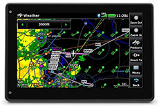
| SIRIUSXM® SERVICE When paired with an optional GDL® 51 or GDL 52 datalink receiver, aera 760 can incorporate SiriusXM satellite weather coverage — plus audio entertainment features. |
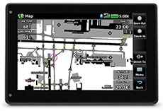
SAFETAXI® DATABASE Upon landing, georeferenced SafeTaxi diagrams on aera 760 automatically help track your location on hundreds of airports and even identify published hot spots. |
SMART AIRSPACE™ Patented Garmin Smart Airspace guidance highlights the airspace nearest your current altitude so you can quickly identify your location relative to the airspace around you. |
 |
 |
 |
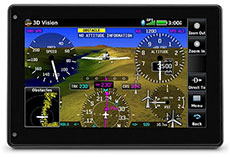
| 3D VISION 3D Vision technology gives you a virtual 3D behind-the-aircraft perspective view of surrounding terrain, obstacles and airports, as well as traffic (when equipped with ADS-B “In”). |
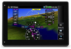
SYNTHETIC VISION View Synthetic Vision (SVX™) by panel-mounting your aera 760 and using its built-in AHRS, or by connecting it to another device with an AHRS, such as a GDL 52 series datalink. |
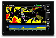
TERRAIN ALERTING See your position above terrain and obstacles on the map and profile view. Obstacles within 1,000 feet (or a pilot-customizable height) are highlighted yellow, while obstacles within 100 feet are highlighted red. |
 |
 |
 |
| WIREAWARE™ Garmin WireAware wire-strike avoidance technology graphically overlays Hazardous Obstacle Transmission (HOT) lines that span rivers and canyons right on the moving map. |
STREET INTERSECTIONS Optional maps allow pilots to enter street intersections and other non-aviation waypoints for easy navigation. |
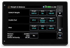
ELECTRONIC FLIGHT BAG The aera 760 fulfills the role of an electronic flight bag, with georeferenced charts, pdf viewer, E6B computer, weight-and-balance calculator, logbook and more. |
 |
 |
 |
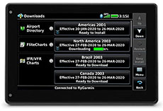
| WI-FI® UPDATES View Internet weather on the ground for pre-flight planning, and update databases at home via Wi-Fi. Plus, stay current throughout the year with a single annual subscription that includes all the databases you need. |
FUEL PRICES Fuel price data can be overlaid on the map for at-a-glance awareness of the prices in an area — or viewed on the airport directory page. |
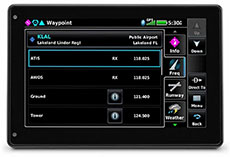
AIRPORT INFORMATION Touch an airport symbol on the map to view its airport information page, and see runways, frequencies, NOTAMs, FBOs and more. |
 |
 |
|
| BATTERY LIFE Get up to 4 hours of flight time on each charge, or easily power it in-flight with a USB-C cable. |
DEDICATED PARTNER aera 760 combines many of the capabilities of panel-mounted avionics with a value-packed, purpose-built package. It’s ready to fly, right out of the box. |
- Physical dimensions: 7.29”W x 4.85”H x 0.91”D (18.5 x 12.3x 2.3 cm)
- Display size: 7" diag (17.8 cm)
- Display resolution, WxH: 480 x 800; portrait and landscape orientation
- Display type: touchscreen WVGA color TFT with white backlight
- Weight: 19.8 oz (561 g)
- Battery: Rechargeable lithium-ion
- Battery life: Up to 4 hours during most daytime conditions, (80% backlight)
- SBAS/WAAS/GLONASS receiver: high-sensitivity with WAAS position accuracy
- Voltage range: 10-35
- IFR or VFR: VFR/IFR
- USB connection: yes (USB-C)
- Expandable memory: yes (microSD™ cards)